Arizona, the sixth-largest US state, encompasses diverse climates and topography. The deserts in the southern portion of the state are some of the hottest and driest areas of the country, while the higher terrain of the Colorado Plateau in the northeast has a cooler climate, with cold winters and mild summers. The mountain ranges that run from the northwest to the southeast experience heavier precipitation and wide temperature variations. Average winter low temperatures range from less than 20°F at high elevations to more than 45°F in southwest Arizona (1991–2020 averages). Typical summer high temperatures range from less than 80°F in the mountains to more than 105°F in desert regions. Phoenix has the hottest climate of all major US cities, and the southern deserts frequently experience summer temperatures exceeding 110°F. Extreme temperatures in Arizona range from a record high of 128°F at Lake Havasu City (June 29, 1994) to a record low of −40°F at Hawley Lake (January 7, 1971). Much of Arizona is characterized as arid or semiarid, with annual average precipitation ranging from less than 4 inches in the southwestern portion of the state to more than 30 inches in the White Mountains in the east-central region. Snowfall is rare in the southern desert region but does occur at the higher elevations, where it can reach depths of more than 100 inches.

Time series of observed and projected temperature change (in degrees Fahrenheit) for Arizona from 1900 to 2100 as described in the caption.
Y-axis values range from negative 4 to positive 18 degrees. Observed annual temperatures from 1900 to 2024 show variability and range from negative 2.0 to positive 3.9 degrees. By the end of the century, projected increases in temperature range from 2.1 to 7.0 degrees under the lower emissions pathway, from 4.2 to 10.0 degrees under the intermediate pathway, and from 8.3 to 16.6 degrees under the higher pathway.
Annual average temperatures in Arizona have increased about 2.5°F since the beginning of the 20th century (Figure 1). The first 25 years of this century have been the warmest period on record for the state. The hottest year on record was 2017, with an annual average temperature of 63.0°F, followed by 2020 (62.6°F) and 2024 (62.5°F). One notable trend is an increase in both summer maximum temperatures (daytime highs) and minimum temperatures (nighttime lows), which has implications for the intensity of future heat waves in a state that already experiences very hot conditions (Figures 2a and 2b).
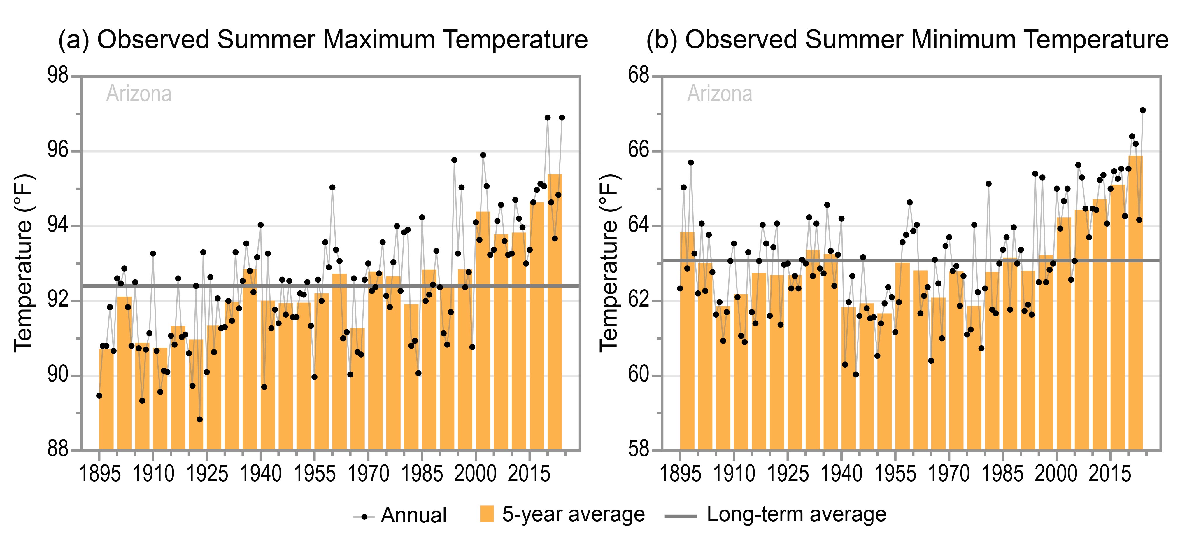
Two graphs of the observed (a) summer maximum and (b) summer minimum temperatures for Arizona from 1895 to 2024 as described in the caption.
Panel A: Summer Maximum Temperature
Y-axis values range from 88 to 98 degrees Fahrenheit. Annual values show year-to-year variability and range from 88.8 to 96.9 degrees. Five-year values also show variability and are mostly below the long-term average of 92.4 degrees between 1895 and 1984 but are all near or above average since 1985. The 1895 to 1899 and 1910 to 1914 periods have the lowest 5-year values at 90.7 and 90.8 degrees, respectively, and the 2015 to 2019 and 2020 to 2024 periods have the at 94.6 and 95.4 degrees, respectively.
Panel B: Summer Minimum TemperatureY-axis values range from 58 to 68 degrees Fahrenheit. Annual values show year-to-year variability and range from 60.0 to 67.1 degrees. Five-year values also show variability and are above the long-term average of 63.1 degrees for the 1895 to 1899 period but are all near or below average between 1900 and 1994 except for the 1930 to 1934 and 1935 to 1929 periods. Since 1995, all 5-year values are near or above average. The 1940 to 1944 and 1950 to 1954 periods have the lowest multiyear values at 61.8 and 61.7 degrees, respectively, and the 2010 to 2014, 2015 to 2019, and 2020 to 2024 periods have the highest at 64.7, 65.1, and 65.9 degrees, respectively.
Since the late 1990s, the number of extremely hot days has generally been near or above average, with the highest 5-year average recorded for the 2020–2024 period (Figure 3a). In 2024, Phoenix experienced 70 days with temperatures of 110°F or higher and set records for the hottest summer and year on record as well as number of consecutive days (113) of 100°F or higher. Statewide, the number of extremely warm nights has been rising steadily since the late 1990s, with the highest 5-year averages recorded since the early 2000s (Figure 3b). This increase in high nighttime temperatures is much larger in the Phoenix metropolitan area. Extreme heat is a particular concern for Phoenix and other urban areas. Heat absorbed and emitted by buildings and pavement, as well as other aspects of urban environments, makes cities even warmer than the surrounding countryside, a phenomenon known as the urban heat island effect. In July 2023, extremely high nighttime and daytime temperatures in the Phoenix area caused serious health impacts. Temperatures in Maricopa County did not drop below 91°F over July 10–25, resulting in more than 300 heat-related deaths. Arizona has also seen an increase in winter temperatures in recent decades. The statewide number of very cold nights has mostly been below average since the 1980s, indicative of warming in the region (Figure 4).

Two graphs of the observed annual number of (a) extremely hot days and (b) extremely warm nights for Arizona from 1930 to 2024 as described in the caption.
Panel A: Extremely Hot Days
Y-axis values range from 20 to 64 days. Annual values show year-to-year variability and range from 22.2 to 61.6 days. Five-year values also show variability and are all below the long-term average of 40.9 days between 1930 and 1949, all above average between 1950 and 1974 except for the 1965 to 1969 period, and all near or below average between 1975 and 1999. Since 2000, 5-year values are all near or above average. The 1930 to 1934 period has the lowest 5-year value at 29.7 days, and the 2020 to 2024 period the highest at 52.9 days.
Panel B: Extremely Warm NightsY-axis values range from 0 to 40 nights. Annual values show year-to-year variability and range from 1.4 to 36.8 nights. Five-year values also show variability as well as an increasing trend across the entire period. Five-year values are all below the long-term average of 12.8 nights between 1930 and 1999 except for the 1980 to 1984 and 1985 to 1989 periods. Since 2000, 5-year values are all above average. The 1935 to 1939 period has the lowest 5-year value at 4.6 nights, and the 2010 to 2014, 2015 to 2019, and 2020 to 2024 periods have the highest at 23.0, 24.25, and 24.26 nights, respectively.

Graph of the observed annual number of very cold nights for Arizona from 1930 to 2024 as described in the caption.
Y-axis values range from 0 to 16 nights. Annual values show year-to-year variability and range from 0.1 to 13.8 nights. Five-year values also show variability and are all above the long-term average of 3.1 nights between 1930 and 1979 except for the 1940 to 1944 and 1955 to 1959 periods. Since 1980, 5-year values are all below average. The 2020 to 2024 period has the lowest 5-year value at 0.9 nights, and the 1930 to 1934 period has the highest at 6.8 nights.
Statewide total annual precipitation is highly variable from year to year, ranging from a low of 6.0 inches in 1956 to a high of 22.8 inches in 1905 (Figure 5); the driest 5-year period occurred in the early 1900s and was immediately followed by the wettest 5-year period. The years since the late 1990s have been relatively dry, with 20 of the last 30 years experiencing below-average precipitation. Unlike many areas of the United States, Arizona and other southwestern states have not experienced an upward trend in the frequency of extreme precipitation events. The number of 1-inch extreme precipitation events has been variable throughout the period of record and shows no long-term trend (Figure 6). Precipitation in the form of snow plays an important role: snowpack is critical for supplying water for both agricultural and urban areas (including Phoenix and Tucson) and is vital for forest health and groundwater recharge across the entire state.

Graph of the total annual precipitation for Arizona from 1895 to 2024 as described in the caption.
Y-axis values range from 4 to 24 inches. Annual values show year-to-year variability and range from 6.0 to 22.8 inches. Five-year values also show variability and are below the long-term average of 12.2 inches between 1895 and 1904, all near or above average between 1905 and 1944, all below average between 1945 and 1964, and all near or above average between 1965 and 1994 except for the 1970 to 1974 period. Since 1995, 5-year values are all near or below average. The 1900 to 1904 period has the lowest 5-year value at 8.6 inches, and the 1905 to 1909 period has the highest at 16.5 inches.

Graph of the observed annual number of 1-inch extreme precipitation events for Arizona from 1930 to 2024 as described in the caption.
Y-axis values range from 0 to 6 events. Annual values show year-to-year variability and range from 0.5 to 4.8 events. Five-year values also show variability and are mostly near or below the long-term average of 2.1 events across the entire period. Exceptions include the 1980 to 1984, 1990 to 1994, and 2010 to 2014 periods, which have the highest 5-year values at 2.7, 3.1, and 2.5 events, respectively. The 1945 to 1949, 1960 to 1964, and 2020 to 2024 periods have the lowest 5-year values at 1.54, 1.49, and 1.5 events, respectively.
An important feature of Arizona’s summer climate is the North American Monsoon, which is a vital source of rainfall from late June or early July to mid-September. Precipitation during the monsoon season is highly variable from year to year but has generally been near or below the long-term average since the early 2000s (Figure 7), although the 2010–2014 period was above average due to warmer sea surface temperatures off the Pacific coast and a very active hurricane season in 2014. In the southernmost portion of the state, monsoon rainfall accounts for more than half of the annual precipitation and plays an important role in supporting agriculture and ecosystems. The monsoon rains are highly beneficial but can occasionally be destructive. On September 8, 2014, extremely heavy monsoon rain associated with a decaying eastern Pacific hurricane caused significant damage and flooding around the Phoenix area. The record for single-day rainfall was broken at several stations, with reports of more than 4 inches. The 2020 monsoon season was the driest on record, with only 1.5 inches of precipitation, well below the previous record low of 2.8 inches in 2009. In 2021, by contrast, the state experienced an active monsoon season, bringing relief to drought-stricken areas such as Tucson, which recorded its seventh-wettest year on record. Some of the rainfall, however, was destructive: Maricopa County saw severe flooding in August, with two deaths and a number of rooftop rescues via helicopter.

Graph of the observed total monsoon-season precipitation for Arizona from 1895 to 2024 as described in the caption.
Y-axis values range from 0 to 10 inches. Annual values show year-to-year variability and range from 1.5 to 8.8 inches. Five-year values also show variability and are below the long-term average of 5.3 inches between 1895 and 1904 but are all above average between 1905 1939. Since 1940, 5-year values are mostly near or below average. One notable exception is the 1980 to 1985 period, which has the highest 5-year value at 6.5 inches. The 1900 to 1904 and 2000 to 2004 periods have the lowest 5-year values at 4.2 and 4.1 inches, respectively.
The historical record indicates periodic prolonged wet and dry periods (Figure 8). Arizona is currently experiencing an extended dry period, with widespread drought conditions persisting across much or all of the state from 2002 to 2025. More than half of Arizona was in extreme drought (defined by the US Drought Monitor) from late 2020 into the summer of 2021. Multiyear periods of high and low precipitation can cause significant variations in reservoir supplies. The latest western US drought has resulted in record-low water levels in Lake Mead, the largest reservoir in the United States. Lake Mead is a critical water resource for Arizona, as well as southern Nevada, southern California, and northern Mexico. Since reaching high levels in the late 1990s, reservoir levels have been falling, reaching a historic low in 2022. In August 2021, a federal water shortage was declared by the US Bureau of Reclamation, resulting in reduced water allocations for Arizona, Nevada, and Mexico (Figure 9). Long-term droughts also raise the risk of wildfires, already a concern for this arid state. In 2011, the Wallow Fire consumed more than 500,000 acres in eastern Arizona, making it the state’s largest wildfire on record. The state also saw active fire seasons in 2020 (with nearly a million acres burned) and 2021 (more than 500,000 acres).

Line graph of the Arizona Palmer Drought Severity Index for the years 1000 to 2024 as described in the caption.
Y-axis values are divided into dry and wet categories, ranging from 0 to negative 8 (dry) and 0 to positive 8 (wet). Annual values show variability and range from negative 6.0 to positive 6.4. Annual values for most years fall between negative 3 and positive 2, but values reaching negative 4 and positive 3 are common. The 20-year running average also shows variability, with values ranging from negative 2.2 to positive 1.9. Since the beginning of the modern era (red line), the running average is generally high in the positive range until dropping below 0 in the 1940s, then rising above 0 in the 1970s. The running average shows a downward trend since the 1990s, reaching a low of negative 1.8 in 2014.
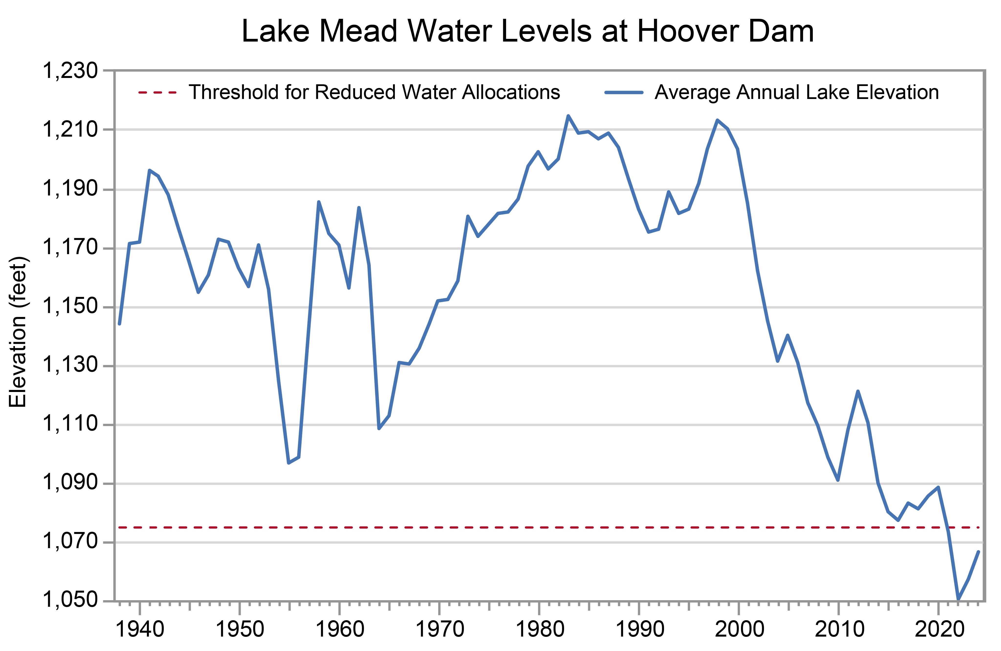
Time series of annual average water levels for Lake Mead at Hoover Dam from 1950 to 2024 as described in the caption.
Y-axis values range from 1,050 to 1,230 feet in elevation. Annual values (blue line) show year-to-year variability and range from a high of 1,215 feet in 1983 to a low of 1,050 feet in 2022. Annual values are mostly between 1,110 and 1,190 feet from the beginning of the period through the early 1970s and mostly between 1,170 and 1,210 feet from the late 1970s through the early 2000s. A steep downward trend is evident since the late 1990s. In 2021, lake elevations crossed the threshold for reduced water allocations (red dashed line) at 1,075 feet and have remained below that threshold ever since; however, a 16-foot rise in elevation to 1,067 feet is shown between 2022 and 2024.
Under the intermediate and higher emissions pathways, historically unprecedented warming is projected during this century (Figure 1). Even under the lower emissions pathway, some projections show annual average temperatures exceeding historical levels by the middle of the century. However, projections for all three pathways show a large range of potential temperature increases, and some projections for the lower pathway are comparable to recent observed values. Rising temperatures will increase the intensity of future heat waves in Arizona.
Under the intermediate emissions pathway, projections of total annual precipitation indicate decreases across most of the state but increases along the northern border by midcentury; however, the projected changes are not statistically significant (Figure 10). There is similar uncertainty in projections for seasonal precipitation, although models generally show statewide increases in fall, statewide decreases in spring, and both increases and decreases in summer and winter. Rising temperatures are expected to raise the snow line (the average lowest elevation at which snow falls) and increase the likelihood that precipitation falls as rain instead of snow. This would reduce water storage in the snowpack, particularly at those lower mountain elevations that are now on the margins of reliable snowpack accumulation. Higher spring temperatures are also expected to result in earlier melting of the snowpack, further decreasing water resources needed for irrigation during the hot summer months.
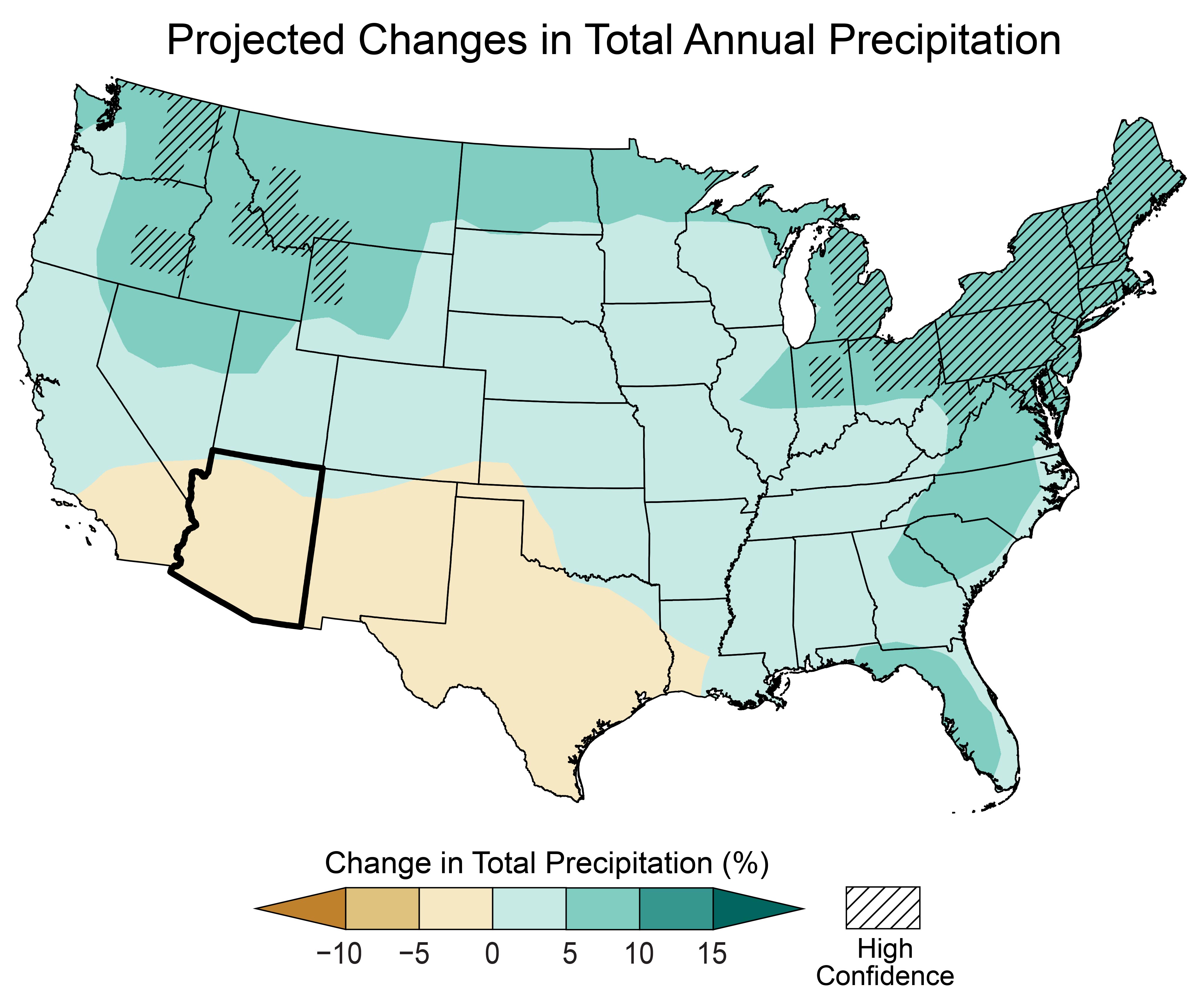
Map of the contiguous United States showing the projected changes in total annual precipitation by the middle of this century as described in the caption. The state of Arizona is outlined in black.
Legend values range from less than negative 10 to greater than positive 15 percent. Note: unless otherwise specified, projected values are not statistically significant.
Arizona
The majority of Arizona is projected to see decreases in total annual precipitation of up to 5 percent, except for a band along the northern border with projected increases of up to 5 percent.
Contiguous US
Projected increases in total annual precipitation are as follows: up to 5 percent for most of the Southeast, as well as the central Midwest, central Great Plains, central West, and Northwest; and 5 to 10 percent for all of the Northeast, as well as portions of the Mid-Atlantic, Southeast, northern Midwest, northern Great Plains, and Pacific Northwest, with statistically significant increases in the 5 to 10 percent range for the Northeast, northeastern Midwest, and portions of the northern Great Plains and Pacific Northwest.
Projected decreases of up to 5 percent are expected across most of Texas, New Mexico, and Arizona, as well as southern California.
As noted earlier, future projections of overall precipitation are uncertain, including those related to the North American Monsoon. However, higher temperatures are expected to intensify naturally occurring droughts, particularly during the cool season, by increasing evaporation rates. This would further reduce streamflow, soil moisture, and water supplies. Continued and more intense drought is expected to challenge limited agricultural resources as well as increase the frequency of dust storms and the risk of very large wildfires.
SOURCES
- Barbero, R., J.T. Abatzoglou, N.K. Larkin, C.A. Kolden, and B. Stocks, 2015: Climate change presents increased potential for very large fires in the contiguous United States. International Journal of Wildland Fire, 24 (7), 892–899. https://doi.org/10.1071/WF15083
- Kunkel, K.E., L.E. Stevens, S.E. Stevens, L. Sun, E. Janssen, D. Wuebbles, K.T. Redmond, and J.G. Dobson, 2013: Regional Climate Trends and Scenarios for the U.S. National Climate Assessment Part 5. Climate of the Southwest U.S. NOAA Technical Report NESDIS 142-5. National Oceanic and Atmospheric Administration, National Environmental Satellite, Data, and Information Service, Washington, DC, 87 pp. https://repository.library.noaa.gov/view/noaa/56810
- MCDPH, 2024: 2023 Heat Related Deaths Report. Department of Public Health, Division of Epidemiology and Informatics, Maricopa County, AZ, 24 pp. https://www.maricopa.gov/ArchiveCenter/ViewFile/Item/5820
- MRCC, n.d.: cli-MATE: MRCC Application Tools Environment. Midwestern Regional Climate Center, accessed November 6, 2025. https://mrcc.purdue.edu/newclimate
- NCDC, n.d.: Climate of Arizona. National Oceanic and Atmospheric Administration, National Climatic Data Center, Asheville, NC, 4 pp. https://www.ncei.noaa.gov/data/climate-normals-deprecated/access/clim60/states/Clim_AZ_01.pdf
- NCEI, n.d.: Climate at a Glance. National Oceanic and Atmospheric Administration, National Centers for Environmental Information, accessed November 6, 2025. https://www.ncei.noaa.gov/access/monitoring/climate-at-a-glance/
- NCEI, n.d.: Drought Variability [Data Access: Palmer Drought Index Studies: North American Drought Atlas (NADA) (Version 2a)]. National Oceanic and Atmospheric Administration, National Centers for Environmental Information, accessed November 6, 2025. https://www.ncei.noaa.gov/products/paleoclimatology/drought-variability
- NCEI, n.d.: National Climate Report. National Oceanic and Atmospheric Administration, National Centers for Environmental Information, accessed November 6, 2025. https://www.ncei.noaa.gov/access/monitoring/monthly-report/national
- NCEI, n.d.: State Climate Extremes Committee (SCEC) Records—Arizona. National Oceanic and Atmospheric Administration, National Centers for Environmental Information, accessed November 6, 2025. https://www.ncei.noaa.gov/access/monitoring/scec/records/az/all
- NCEI, n.d.: Storm Events Database. National Oceanic and Atmospheric Administration, National Centers for Environmental Information, accessed November 6, 2025. https://www.ncei.noaa.gov/stormevents/
- NCEI, n.d.: U.S. Climate Normals. National Oceanic and Atmospheric Administration, National Centers for Environmental Information, accessed November 6, 2025. https://www.ncei.noaa.gov/products/land-based-station/us-climate-normals
- NCEI, n.d.: Wildfires Report. National Oceanic and Atmospheric Administration, National Centers for Environmental Information, accessed November 6, 2025. https://www.ncei.noaa.gov/access/monitoring/monthly-report/fire
- NICC, 2020: Wildland Fire Summary and Statistics Annual Report 2020. National Interagency Fire Center, National Interagency Coordination Center, 52 pp. https://www.nifc.gov/sites/default/files/NICC/2-Predictive%20Services/Intelligence/Annual%20Reports/2020/annual_report_0.pdf
- NIDIS, n.d.: National Conditions: Arizona. National Oceanic and Atmospheric Administration, National Integrated Drought Information System, accessed November 6, 2025. https://www.drought.gov/states/arizona
- NPS, n.d.: Lake Mead: Lowering Lake Levels. National Park Service, Washington, DC, accessed November 6, 2025. https://www.nps.gov/lake/learn/nature/lowering-lake-levels.htm
- NWS, n.d.: March 1–2, 2023: Low-Elevation Snowfall Event. National Oceanic and Atmospheric Administration, National Weather Service, Phoenix Weather Forecast Office, Tempe, AZ, accessed November 6, 2025. https://www.weather.gov/psr/Mar22023
- USBR, 2021: Reclamation announces 2022 operating conditions for Lake Powell and Lake Mead. U.S. Bureau of Reclamation, Boulder City, NV, August 16, 2021. https://www.usbr.gov/newsroom/news-release/3950
- USBR, n.d.: Lake Mead Annual High and Low Elevations (1935–2020). U.S. Bureau of Reclamation, Lower Colorado Basin Region, Boulder City, NV, 1 pp. https://www.usbr.gov/lc/region/g4000/lakemead_bar.pdf
- USBR, n.d.: Lower Colorado River Operations: Lake Mead At Hoover Dam, End of Month Elevation (FEET). U.S. Bureau of Reclamation, accessed November 6, 2025. https://www.usbr.gov/lc/region/g4000/hourly/mead-elv.html
- USGCRP, 2017: Climate Science Special Report: Fourth National Climate Assessment, Volume I. Wuebbles, D.J., D.W. Fahey, K.A. Hibbard, D.J. Dokken, B.C. Stewart, and T.K. Maycock, Eds. U.S. Global Change Research Program, Washington, DC, USA, 470 pp. https://repository.library.noaa.gov/view/noaa/19486
- USGCRP, 2018: Impacts, Risks, and Adaptation in the United States: Fourth National Climate Assessment, Volume II. Reidmiller, D.R., C.W. Avery, D.R. Easterling, K.E. Kunkel, K.L.M. Lewis, T.K. Maycock, and B.C. Stewart, Eds. U.S. Global Change Research Program, Washington, DC, USA, 1515 pp. https://repository.library.noaa.gov/view/noaa/19487
- USGCRP, 2023: Fifth National Climate Assessment. Crimmins, A.R., C.W. Avery, D.R. Easterling, K.E. Kunkel, B.C. Stewart, and T.K. Maycock, Eds. U.S. Global Change Research Program, Washington, DC, USA. https://repository.library.noaa.gov/view/noaa/61592